![Stanford's Compendium of Geography and Travel based on Hellwald's “Die Erde und ihre Völker” (1878) by Edward…]() Stanford's Compendium of Geography and Travel based on Hellwald's “Die Erde und ihre Völker” (1878) by Edward…
Stanford's Compendium of Geography and Travel based on Hellwald's “Die Erde und ihre Völker” (1878) by Edward…![Sterrenkaart van de noordelijke sterrenhemel (ca. 1722–1750) by Carel Allard. Original from The Rijksmuseum. Digitally…]() Sterrenkaart van de noordelijke sterrenhemel (ca. 1722–1750) by Carel Allard. Original from The Rijksmuseum. Digitally…
Sterrenkaart van de noordelijke sterrenhemel (ca. 1722–1750) by Carel Allard. Original from The Rijksmuseum. Digitally…![Bacon's standard map of Europe vintage vector, remix from original artwork.]() Bacon's standard map of Europe vintage vector, remix from original artwork.
Bacon's standard map of Europe vintage vector, remix from original artwork.![Hemelkaart met de noordelijke en zuidelijke sterrenbeelden (1705) by Pieter Schenk (I). Original from The Rijksmuseum.…]() Hemelkaart met de noordelijke en zuidelijke sterrenbeelden (1705) by Pieter Schenk (I). Original from The Rijksmuseum.…
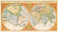
Hemelkaart met de noordelijke en zuidelijke sterrenbeelden (1705) by Pieter Schenk (I). Original from The Rijksmuseum.…![Map of the World, vintage illustration by Karel Allard. Remixed by rawpixel.]() Map of the World, vintage illustration by Karel Allard. Remixed by rawpixel.
Map of the World, vintage illustration by Karel Allard. Remixed by rawpixel.![Snow covered Alps of France, Italy, and Switzerland. Original from NASA. Digitally enhanced by rawpixel.]() Snow covered Alps of France, Italy, and Switzerland. Original from NASA. Digitally enhanced by rawpixel.
Snow covered Alps of France, Italy, and Switzerland. Original from NASA. Digitally enhanced by rawpixel.![The Story of Atlantis: a geographical, historical, and ethnological sketch. Illustrated by four maps of the world's…]() The Story of Atlantis: a geographical, historical, and ethnological sketch. Illustrated by four maps of the world's…
The Story of Atlantis: a geographical, historical, and ethnological sketch. Illustrated by four maps of the world's…![Orient Line Guide. Chapters for travellers by sea and by land (1885) by William John Loftie. Original from British Library.…]() Orient Line Guide. Chapters for travellers by sea and by land (1885) by William John Loftie. Original from British Library.…
Orient Line Guide. Chapters for travellers by sea and by land (1885) by William John Loftie. Original from British Library.…![Eid Mubarak Instagram story template]() Eid Mubarak Instagram story template
Eid Mubarak Instagram story templateTrending Design
![The Commerce and Navigation of the Ancients in the Indian Ocean (1807) by William Vincent. Original from British Library.…]() The Commerce and Navigation of the Ancients in the Indian Ocean (1807) by William Vincent. Original from British Library.…
The Commerce and Navigation of the Ancients in the Indian Ocean (1807) by William Vincent. Original from British Library.…![Map of Kyoto (1863) by Takebara Kahei. Original from The Beinecke Rare Book & Manuscript Library. Digitally enhanced by…]() Map of Kyoto (1863) by Takebara Kahei. Original from The Beinecke Rare Book & Manuscript Library. Digitally enhanced by…
Map of Kyoto (1863) by Takebara Kahei. Original from The Beinecke Rare Book & Manuscript Library. Digitally enhanced by…![Bacon's standard map of Europe vintage illustration, remix from original artwork.]() Bacon's standard map of Europe vintage illustration, remix from original artwork.
Bacon's standard map of Europe vintage illustration, remix from original artwork.![Map of New York and vicinity (1875) by Matthew Dripps. Original from The Beinecke Rare Book & Manuscript Library. Digitally…]() Map of New York and vicinity (1875) by Matthew Dripps. Original from The Beinecke Rare Book & Manuscript Library. Digitally…
Map of New York and vicinity (1875) by Matthew Dripps. Original from The Beinecke Rare Book & Manuscript Library. Digitally…![Kaart van Nederland met de marsroutes van het Franse leger (1792) by Cornelis van Baarsel. Original from The Rijksmuseum.…]() Kaart van Nederland met de marsroutes van het Franse leger (1792) by Cornelis van Baarsel. Original from The Rijksmuseum.…
Kaart van Nederland met de marsroutes van het Franse leger (1792) by Cornelis van Baarsel. Original from The Rijksmuseum.…![The First and Second Battles of Newbury and the Siege of Donnington Castle during the Civil War, A.D. 1643–1646 (1881)…]() The First and Second Battles of Newbury and the Siege of Donnington Castle during the Civil War, A.D. 1643–1646 (1881)…
The First and Second Battles of Newbury and the Siege of Donnington Castle during the Civil War, A.D. 1643–1646 (1881)…![Geography of the British Isles from ten different standpoints, with twenty-one maps (1886) by Thomas McLaren Davidson.…]() Geography of the British Isles from ten different standpoints, with twenty-one maps (1886) by Thomas McLaren Davidson.…
Geography of the British Isles from ten different standpoints, with twenty-one maps (1886) by Thomas McLaren Davidson.…![View of Antwerp from Braun and Hogenberg's Civitates Orbis Terrarum (1572–1594) designed by Joris Hoefnagel and edited…]() View of Antwerp from Braun and Hogenberg's Civitates Orbis Terrarum (1572–1594) designed by Joris Hoefnagel and edited…
View of Antwerp from Braun and Hogenberg's Civitates Orbis Terrarum (1572–1594) designed by Joris Hoefnagel and edited…![Kaart van de noordkust van Engeland bij Newcastle upon Tyne (1580–1583) by Joannes van Doetechum (I). Original from…]() Kaart van de noordkust van Engeland bij Newcastle upon Tyne (1580–1583) by Joannes van Doetechum (I). Original from…
Kaart van de noordkust van Engeland bij Newcastle upon Tyne (1580–1583) by Joannes van Doetechum (I). Original from…![Poster "Irish Free State & Northern Ireland" (1929) by MacDonald Gil. Original from Museum of New Zealand. Digitally…]() Poster "Irish Free State & Northern Ireland" (1929) by MacDonald Gil. Original from Museum of New Zealand. Digitally…
Poster "Irish Free State & Northern Ireland" (1929) by MacDonald Gil. Original from Museum of New Zealand. Digitally…![Map of Alexandria (1575) by Georg Braun. Original from The MET Museum. Digitally enhanced by rawpixel.]() Map of Alexandria (1575) by Georg Braun. Original from The MET Museum. Digitally enhanced by rawpixel.
Map of Alexandria (1575) by Georg Braun. Original from The MET Museum. Digitally enhanced by rawpixel.![Kaart van het zuidelijke deel van Zuid-Amerika (1750–1760) by Guillaume Delisle. Original from The Rijksmuseum.…]() Kaart van het zuidelijke deel van Zuid-Amerika (1750–1760) by Guillaume Delisle. Original from The Rijksmuseum.…
Kaart van het zuidelijke deel van Zuid-Amerika (1750–1760) by Guillaume Delisle. Original from The Rijksmuseum.…![Map of Vienna (ca. 1702) by Johann-Baptista Homann. Original from Yale University Art Gallery. Digitally enhanced by…]() Map of Vienna (ca. 1702) by Johann-Baptista Homann. Original from Yale University Art Gallery. Digitally enhanced by…
Map of Vienna (ca. 1702) by Johann-Baptista Homann. Original from Yale University Art Gallery. Digitally enhanced by…![Getekende kaart van de Franse linies in Brabant (ca. 1705) by anonymous. Original from The Rijksmuseum. Digitally enhanced…]() Getekende kaart van de Franse linies in Brabant (ca. 1705) by anonymous. Original from The Rijksmuseum. Digitally enhanced…
Getekende kaart van de Franse linies in Brabant (ca. 1705) by anonymous. Original from The Rijksmuseum. Digitally enhanced…![Les Isles Britanniques: ou sont le Royaume d'Angleterre tire ́de Sped celuy d'Ecosse tire ́de Th. Pont et celuy d'Irlande…]() Les Isles Britanniques: ou sont le Royaume d'Angleterre tire ́de Sped celuy d'Ecosse tire ́de Th. Pont et celuy d'Irlande…
Les Isles Britanniques: ou sont le Royaume d'Angleterre tire ́de Sped celuy d'Ecosse tire ́de Th. Pont et celuy d'Irlande…![Kaartje van Kaap de Goede Hoop (1595) by anonymous. Original from The Rijksmuseum. Digitally enhanced by rawpixel.]() Kaartje van Kaap de Goede Hoop (1595) by anonymous. Original from The Rijksmuseum. Digitally enhanced by rawpixel.
Kaartje van Kaap de Goede Hoop (1595) by anonymous. Original from The Rijksmuseum. Digitally enhanced by rawpixel.![Map of China (1848) by James Wyld. Original from The Beinecke Rare Book & Manuscript Library. Digitally enhanced by rawpixel.]() Map of China (1848) by James Wyld. Original from The Beinecke Rare Book & Manuscript Library. Digitally enhanced by rawpixel.
Map of China (1848) by James Wyld. Original from The Beinecke Rare Book & Manuscript Library. Digitally enhanced by rawpixel.![Map of Africa (1722). Original from The Beinecke Rare Book & Manuscript Library. Digitally enhanced by rawpixel.]() Map of Africa (1722). Original from The Beinecke Rare Book & Manuscript Library. Digitally enhanced by rawpixel.
Map of Africa (1722). Original from The Beinecke Rare Book & Manuscript Library. Digitally enhanced by rawpixel.![Kaart van Griekenland by Abraham Ortelius (1527–1598). Original from The Rijksmuseum. Digitally enhanced by rawpixel.]() Kaart van Griekenland by Abraham Ortelius (1527–1598). Original from The Rijksmuseum. Digitally enhanced by rawpixel.
Kaart van Griekenland by Abraham Ortelius (1527–1598). Original from The Rijksmuseum. Digitally enhanced by rawpixel.![Eastern division of Paris: containing the Quartiers (1834) by W. B. Clarke and James Shury. Original from Library of…]() Eastern division of Paris: containing the Quartiers (1834) by W. B. Clarke and James Shury. Original from Library of…
Eastern division of Paris: containing the Quartiers (1834) by W. B. Clarke and James Shury. Original from Library of…![My first love is music Instagram story template]() My first love is music Instagram story template
My first love is music Instagram story templateTrending Design
![La pianta grande di Roma (The Large Plan of Rome), also known as The Nolli Map by Pietro Campana, Carlo Nolli, and Rocco…]() La pianta grande di Roma (The Large Plan of Rome), also known as The Nolli Map by Pietro Campana, Carlo Nolli, and Rocco…
La pianta grande di Roma (The Large Plan of Rome), also known as The Nolli Map by Pietro Campana, Carlo Nolli, and Rocco…![Sterrenkaart van de zuidelijke sterrenhemel (ca. 1722–1750) by Carel Allard. Original from The Rijksmuseum. Digitally…]() Sterrenkaart van de zuidelijke sterrenhemel (ca. 1722–1750) by Carel Allard. Original from The Rijksmuseum. Digitally…
Sterrenkaart van de zuidelijke sterrenhemel (ca. 1722–1750) by Carel Allard. Original from The Rijksmuseum. Digitally…![Map of South America illustration, vintage artwork by Samuel Augustus Mitchell, remixed by rawpixel]() Map of South America illustration, vintage artwork by Samuel Augustus Mitchell, remixed by rawpixel
Map of South America illustration, vintage artwork by Samuel Augustus Mitchell, remixed by rawpixel![People holding pins for location and a world map]() People holding pins for location and a world map
People holding pins for location and a world map![People with world map and pushpin icons]() People with world map and pushpin icons
People with world map and pushpin icons![Geographische Naturkunde oder Grundzüge einer Allgemeinen Naturgeschichte der drei Reiche, mit physiognomischer Schilderung…]() Geographische Naturkunde oder Grundzüge einer Allgemeinen Naturgeschichte der drei Reiche, mit physiognomischer Schilderung…
Geographische Naturkunde oder Grundzüge einer Allgemeinen Naturgeschichte der drei Reiche, mit physiognomischer Schilderung…![Plattegrond van Béthune (1710) by anonymous. Original from The Rijksmuseum. Digitally enhanced by rawpixel.]() Plattegrond van Béthune (1710) by anonymous. Original from The Rijksmuseum. Digitally enhanced by rawpixel.
Plattegrond van Béthune (1710) by anonymous. Original from The Rijksmuseum. Digitally enhanced by rawpixel.![A Map of the Winds (1740) by Matthaeo Seuttero. Original from The Beinecke Rare Book & Manuscript Library. Digitally…]() A Map of the Winds (1740) by Matthaeo Seuttero. Original from The Beinecke Rare Book & Manuscript Library. Digitally…
A Map of the Winds (1740) by Matthaeo Seuttero. Original from The Beinecke Rare Book & Manuscript Library. Digitally…![Map of Asia. Identical to the maps of Guillaume D'Isle (ca.1723). Original from British Library. Digitally enhanced by…]() Map of Asia. Identical to the maps of Guillaume D'Isle (ca.1723). Original from British Library. Digitally enhanced by…
Map of Asia. Identical to the maps of Guillaume D'Isle (ca.1723). Original from British Library. Digitally enhanced by…![The City of New York: Longworth's Explanatory Map and Plan (1817) by David Longworth. Original from The MET Museum.…]() The City of New York: Longworth's Explanatory Map and Plan (1817) by David Longworth. Original from The MET Museum.…
The City of New York: Longworth's Explanatory Map and Plan (1817) by David Longworth. Original from The MET Museum.…![Poster "A Map of New Zealand" (1913) by MacDonald Gil. Original from Museum of New Zealand. Digitally enhanced by rawpixel.]() Poster "A Map of New Zealand" (1913) by MacDonald Gil. Original from Museum of New Zealand. Digitally enhanced by rawpixel.
Poster "A Map of New Zealand" (1913) by MacDonald Gil. Original from Museum of New Zealand. Digitally enhanced by rawpixel.![Kaart van de Zuidengelse kust tussen de Isle of Wight en Dover (ca. 1580–1583) by Joannes van Doetechum (I). Original…]() Kaart van de Zuidengelse kust tussen de Isle of Wight en Dover (ca. 1580–1583) by Joannes van Doetechum (I). Original…
Kaart van de Zuidengelse kust tussen de Isle of Wight en Dover (ca. 1580–1583) by Joannes van Doetechum (I). Original…![Kaart van Zeeland (1592) by Frans Hogenberg. Original from The Rijksmuseum. Digitally enhanced by rawpixel.]() Kaart van Zeeland (1592) by Frans Hogenberg. Original from The Rijksmuseum. Digitally enhanced by rawpixel.
Kaart van Zeeland (1592) by Frans Hogenberg. Original from The Rijksmuseum. Digitally enhanced by rawpixel.![Kaart van de aarde met de verschillende standen van de maan en de zon (1708) by Johannes van Loon. Original from The…]() Kaart van de aarde met de verschillende standen van de maan en de zon (1708) by Johannes van Loon. Original from The…
Kaart van de aarde met de verschillende standen van de maan en de zon (1708) by Johannes van Loon. Original from The…![Reduced ordnance map of London (1879) by J. Whitbread. Original from The Beinecke Rare Book & Manuscript Library. Digitally…]() Reduced ordnance map of London (1879) by J. Whitbread. Original from The Beinecke Rare Book & Manuscript Library. Digitally…
Reduced ordnance map of London (1879) by J. Whitbread. Original from The Beinecke Rare Book & Manuscript Library. Digitally…![Beeton's Dictionary of Geography. A universal gazetteer. Illustrated by maps (1868) by Samuel Orchart Beeton. Original from…]() Beeton's Dictionary of Geography. A universal gazetteer. Illustrated by maps (1868) by Samuel Orchart Beeton. Original from…
Beeton's Dictionary of Geography. A universal gazetteer. Illustrated by maps (1868) by Samuel Orchart Beeton. Original from…![Kaart van het Noordpoolgebied (1598) by Willem Barendsz. Original from The Rijksmuseum. Digitally enhanced by rawpixel.]() Kaart van het Noordpoolgebied (1598) by Willem Barendsz. Original from The Rijksmuseum. Digitally enhanced by rawpixel.
Kaart van het Noordpoolgebied (1598) by Willem Barendsz. Original from The Rijksmuseum. Digitally enhanced by rawpixel.![Kaart van de kusten van Vlaanderen, Normandië en Engeland (ca. 1580–1581) by Joannes van Doetechum (I). Original…]() Kaart van de kusten van Vlaanderen, Normandië en Engeland (ca. 1580–1581) by Joannes van Doetechum (I). Original…
Kaart van de kusten van Vlaanderen, Normandië en Engeland (ca. 1580–1581) by Joannes van Doetechum (I). Original…![Map of Kyoto (1863) by Takebara Kahei. Original from The Beinecke Rare Book & Manuscript Library. Digitally enhanced by…]() Map of Kyoto (1863) by Takebara Kahei. Original from The Beinecke Rare Book & Manuscript Library. Digitally enhanced by…
Map of Kyoto (1863) by Takebara Kahei. Original from The Beinecke Rare Book & Manuscript Library. Digitally enhanced by…![Strategic map of Central Europe showing the international frontiers / prepared in the War College Division (1915) by Arch.…]() Strategic map of Central Europe showing the international frontiers / prepared in the War College Division (1915) by Arch.…
Strategic map of Central Europe showing the international frontiers / prepared in the War College Division (1915) by Arch.…![Pink rose pattern phone wallpaper, Valentine's flower background, editable design]() Pink rose pattern phone wallpaper, Valentine's flower background, editable design
Pink rose pattern phone wallpaper, Valentine's flower background, editable designTrending Design
![La Halle aux Blés, Street Plan (ca. 1810) by Pierre François Léonard Fontaine. Original from The MET…]() La Halle aux Blés, Street Plan (ca. 1810) by Pierre François Léonard Fontaine. Original from The MET…
La Halle aux Blés, Street Plan (ca. 1810) by Pierre François Léonard Fontaine. Original from The MET…![Gazetteer of the British Isles, statistical and topographical by John Bartholomew (1887). Original from British Library.…]() Gazetteer of the British Isles, statistical and topographical by John Bartholomew (1887). Original from British Library.…
Gazetteer of the British Isles, statistical and topographical by John Bartholomew (1887). Original from British Library.…![Kaart van Noord-Amerika (1735) from erven J. Ratelband & Co. Original from The Rijksmuseum. Digitally enhanced by rawpixel.]() Kaart van Noord-Amerika (1735) from erven J. Ratelband & Co. Original from The Rijksmuseum. Digitally enhanced by rawpixel.
Kaart van Noord-Amerika (1735) from erven J. Ratelband & Co. Original from The Rijksmuseum. Digitally enhanced by rawpixel.![Plattegrond van Amsterdam met verdeling in halve brigades en bataljons van de Nationale Garde (1795) by Cornelis van…]() Plattegrond van Amsterdam met verdeling in halve brigades en bataljons van de Nationale Garde (1795) by Cornelis van…
Plattegrond van Amsterdam met verdeling in halve brigades en bataljons van de Nationale Garde (1795) by Cornelis van…![Diverse people pointing at the world map]() Diverse people pointing at the world map
Diverse people pointing at the world map![Portolan atlas of the Mediterranean Sea, western Europe, and the northwest coast of Africa: World map drawn on an oval…]() Portolan atlas of the Mediterranean Sea, western Europe, and the northwest coast of Africa: World map drawn on an oval…
Portolan atlas of the Mediterranean Sea, western Europe, and the northwest coast of Africa: World map drawn on an oval…![Bacon's standard map of Europe vintage illustration wall art print and poster design remix from original artwork.]() Bacon's standard map of Europe vintage illustration wall art print and poster design remix from original artwork.
Bacon's standard map of Europe vintage illustration wall art print and poster design remix from original artwork.![清 佚名 台南地區荷蘭城堡 Forts Zeelandia and Provintia and the City of Tainan (ca. 1900s) by anonymous. Original from The MET Museum.…]() 清 佚名 台南地區荷蘭城堡 Forts Zeelandia and Provintia and the City of Tainan (ca. 1900s) by anonymous. Original from The MET Museum.…
清 佚名 台南地區荷蘭城堡 Forts Zeelandia and Provintia and the City of Tainan (ca. 1900s) by anonymous. Original from The MET Museum.…![Map of the World png, vintage illustration by Karel Allard, transparent background. Remixed by rawpixel.]() Map of the World png, vintage illustration by Karel Allard, transparent background. Remixed by rawpixel.
Map of the World png, vintage illustration by Karel Allard, transparent background. Remixed by rawpixel.![Map of the World png, vintage illustration by Karel Allard, transparent background. Remixed by rawpixel.]() Map of the World png, vintage illustration by Karel Allard, transparent background. Remixed by rawpixel.
Map of the World png, vintage illustration by Karel Allard, transparent background. Remixed by rawpixel.![Map of China by Katsushika Hokusai (1760–1849). Original from Yale University Art Gallery. Digitally enhanced by…]() Map of China by Katsushika Hokusai (1760–1849). Original from Yale University Art Gallery. Digitally enhanced by…
Map of China by Katsushika Hokusai (1760–1849). Original from Yale University Art Gallery. Digitally enhanced by…![Noordpool (ca. 1869–1907) by Nijgh & Van Ditmar. Original from The Rijksmuseum. Digitally enhanced by rawpixel.]() Noordpool (ca. 1869–1907) by Nijgh & Van Ditmar. Original from The Rijksmuseum. Digitally enhanced by rawpixel.
Noordpool (ca. 1869–1907) by Nijgh & Van Ditmar. Original from The Rijksmuseum. Digitally enhanced by rawpixel.![World map png sticker, transparent background]() World map png sticker, transparent background
World map png sticker, transparent background![Jardin Public, Champs Elysées byCharles Motte (1785–1836). Original from The MET Museum. Digitally enhanced by…]() Jardin Public, Champs Elysées byCharles Motte (1785–1836). Original from The MET Museum. Digitally enhanced by…
Jardin Public, Champs Elysées byCharles Motte (1785–1836). Original from The MET Museum. Digitally enhanced by…![Eastern Hemisphere (1808) by C. Smith. Original from The Beinecke Rare Book & Manuscript Library. Digitally enhanced by…]() Eastern Hemisphere (1808) by C. Smith. Original from The Beinecke Rare Book & Manuscript Library. Digitally enhanced by…
Eastern Hemisphere (1808) by C. Smith. Original from The Beinecke Rare Book & Manuscript Library. Digitally enhanced by…![World map (1900) by Diogo Ribeiro. Original from The Beinecke Rare Book & Manuscript Library. Digitally enhanced by rawpixel.]() World map (1900) by Diogo Ribeiro. Original from The Beinecke Rare Book & Manuscript Library. Digitally enhanced by rawpixel.
World map (1900) by Diogo Ribeiro. Original from The Beinecke Rare Book & Manuscript Library. Digitally enhanced by rawpixel.![Gazetteer of the British Isles, statistical and topographical (1887) by John Bartholomew. Original from British Library.…]() Gazetteer of the British Isles, statistical and topographical (1887) by John Bartholomew. Original from British Library.…
Gazetteer of the British Isles, statistical and topographical (1887) by John Bartholomew. Original from British Library.…![S. Beati Liebanensis mappam mundi ad exemplar ecclesiae Snacto Severi, quod nunc Parisiis asservatur, primum integram edidit…]() S. Beati Liebanensis mappam mundi ad exemplar ecclesiae Snacto Severi, quod nunc Parisiis asservatur, primum integram edidit…
S. Beati Liebanensis mappam mundi ad exemplar ecclesiae Snacto Severi, quod nunc Parisiis asservatur, primum integram edidit…![A new map of England (1811) by John Cary. Original from The Beinecke Rare Book & Manuscript Library. Digitally enhanced by…]() A new map of England (1811) by John Cary. Original from The Beinecke Rare Book & Manuscript Library. Digitally enhanced by…
A new map of England (1811) by John Cary. Original from The Beinecke Rare Book & Manuscript Library. Digitally enhanced by…![Kaart van de kust van Zweden tussen Kalmar en Stockholm (ca. 1580–1583) by Joannes van Doetechum (I). Original from…]() Kaart van de kust van Zweden tussen Kalmar en Stockholm (ca. 1580–1583) by Joannes van Doetechum (I). Original from…
Kaart van de kust van Zweden tussen Kalmar en Stockholm (ca. 1580–1583) by Joannes van Doetechum (I). Original from…![Collage art social story template, surreal quote design]() Collage art social story template, surreal quote design
Collage art social story template, surreal quote designTrending Design
![Map of the World, vintage illustration by Karel Allard. Remixed by rawpixel.]() Map of the World, vintage illustration by Karel Allard. Remixed by rawpixel.
Map of the World, vintage illustration by Karel Allard. Remixed by rawpixel.![Map of the World, vintage illustration psd by Karel Allard. Remixed by rawpixel.]() Map of the World, vintage illustration psd by Karel Allard. Remixed by rawpixel.
Map of the World, vintage illustration psd by Karel Allard. Remixed by rawpixel.![Map of the World, vintage illustration psd by Karel Allard. Remixed by rawpixel.]() Map of the World, vintage illustration psd by Karel Allard. Remixed by rawpixel.
Map of the World, vintage illustration psd by Karel Allard. Remixed by rawpixel.![New twelve inch terrestrial globe (ca. 1891) by Rand McNally & Company. Original from Library of Congress. Digitally…]() New twelve inch terrestrial globe (ca. 1891) by Rand McNally & Company. Original from Library of Congress. Digitally…
New twelve inch terrestrial globe (ca. 1891) by Rand McNally & Company. Original from Library of Congress. Digitally…![Green Cartography Of The World In A White Background]() Green Cartography Of The World In A White Background
Green Cartography Of The World In A White Background![War Map of Europe: As seen through French eyes by Paul Hadol. Original from Library of Congress. Digitally enhanced by…]() War Map of Europe: As seen through French eyes by Paul Hadol. Original from Library of Congress. Digitally enhanced by…
War Map of Europe: As seen through French eyes by Paul Hadol. Original from Library of Congress. Digitally enhanced by…![Route and Surveys of the Southern Journey Party, 1908–1909 (1909) by England: Royal Geographic Society. Original from…]() Route and Surveys of the Southern Journey Party, 1908–1909 (1909) by England: Royal Geographic Society. Original from…
Route and Surveys of the Southern Journey Party, 1908–1909 (1909) by England: Royal Geographic Society. Original from…![National Flags by an unknown artist, showing emblems and flags of different countries. Original from Library of Congress.…]() National Flags by an unknown artist, showing emblems and flags of different countries. Original from Library of Congress.…
National Flags by an unknown artist, showing emblems and flags of different countries. Original from Library of Congress.…![Map of South America png sticker, vintage artwork by Samuel Augustus Mitchell, transparent background, remixed by rawpixel]() Map of South America png sticker, vintage artwork by Samuel Augustus Mitchell, transparent background, remixed by rawpixel
Map of South America png sticker, vintage artwork by Samuel Augustus Mitchell, transparent background, remixed by rawpixel![Vintage brown world map background. Remixed by rawpixel.]() Vintage brown world map background. Remixed by rawpixel.
Vintage brown world map background. Remixed by rawpixel. ![Vintage brown world map background. Remixed by rawpixel.]() Vintage brown world map background. Remixed by rawpixel.
Vintage brown world map background. Remixed by rawpixel. ![Poster "A Map of Australia" (1930) by MacDonald Gil. Original from Museum of New Zealand. Digitally enhanced by rawpixel.]() Poster "A Map of Australia" (1930) by MacDonald Gil. Original from Museum of New Zealand. Digitally enhanced by rawpixel.
Poster "A Map of Australia" (1930) by MacDonald Gil. Original from Museum of New Zealand. Digitally enhanced by rawpixel.![Maan en Eclipswyzer (1695) by Caspar Luyken. Original from The Rijksmuseum. Digitally enhanced by rawpixel.]() Maan en Eclipswyzer (1695) by Caspar Luyken. Original from The Rijksmuseum. Digitally enhanced by rawpixel.
Maan en Eclipswyzer (1695) by Caspar Luyken. Original from The Rijksmuseum. Digitally enhanced by rawpixel.![Blue Cartography Of The World In A White Background]() Blue Cartography Of The World In A White Background
Blue Cartography Of The World In A White Background![Map of South America collage element psd, vintage artwork by Samuel Augustus Mitchell, remixed by rawpixel]() Map of South America collage element psd, vintage artwork by Samuel Augustus Mitchell, remixed by rawpixel
Map of South America collage element psd, vintage artwork by Samuel Augustus Mitchell, remixed by rawpixel![Vintage globe ball psd. Remixed by rawpixel.]() Vintage globe ball psd. Remixed by rawpixel.
Vintage globe ball psd. Remixed by rawpixel. ![Sphaerarum artificialium typica repraesentatio (1712) from Johann Baptista Homann. Original from The Rijksmuseum. Digitally…]() Sphaerarum artificialium typica repraesentatio (1712) from Johann Baptista Homann. Original from The Rijksmuseum. Digitally…
Sphaerarum artificialium typica repraesentatio (1712) from Johann Baptista Homann. Original from The Rijksmuseum. Digitally…![Noua, et integra uniuersi orbis descriptio (1531) by Oronce Finé. Original from Library of Congress. Digitally…]() Noua, et integra uniuersi orbis descriptio (1531) by Oronce Finé. Original from Library of Congress. Digitally…
Noua, et integra uniuersi orbis descriptio (1531) by Oronce Finé. Original from Library of Congress. Digitally…![A new mapp of America devided according to the best and latest observations and discoveries wherein are…]() A new mapp of America devided according to the best and latest observations and discoveries wherein are…
A new mapp of America devided according to the best and latest observations and discoveries wherein are…![Vintage globe ball png geography, transparent background. Remixed by rawpixel.]() Vintage globe ball png geography, transparent background. Remixed by rawpixel.
Vintage globe ball png geography, transparent background. Remixed by rawpixel. ![Paris Map in Dutch vintage illustration by Guillaume Delisle. Digitally enhanced by rawpixel.]() Paris Map in Dutch vintage illustration by Guillaume Delisle. Digitally enhanced by rawpixel.
Paris Map in Dutch vintage illustration by Guillaume Delisle. Digitally enhanced by rawpixel.![Illustration of world map isolated]() Illustration of world map isolated
Illustration of world map isolated![Two Paintings of Deer Antlers (ca. 1762–1767) by The Qianlong Emperor. Original from The MET Museum. Digitally…]() Two Paintings of Deer Antlers (ca. 1762–1767) by The Qianlong Emperor. Original from The MET Museum. Digitally…
Two Paintings of Deer Antlers (ca. 1762–1767) by The Qianlong Emperor. Original from The MET Museum. Digitally…![Travel Travelling Map Route Journey Concept]() Travel Travelling Map Route Journey Concept
Travel Travelling Map Route Journey Concept![Universal Atlas of the World, A cartographic map of the British Isles. published in 1900. Digitally enhanced from our own…]() Universal Atlas of the World, A cartographic map of the British Isles. published in 1900. Digitally enhanced from our own…
Universal Atlas of the World, A cartographic map of the British Isles. published in 1900. Digitally enhanced from our own…![Amsterdam canal houses by Johan Teyler (1648 -1709). Original from The Rijksmuseum. Digitally enhanced by rawpixel.]() Amsterdam canal houses by Johan Teyler (1648 -1709). Original from The Rijksmuseum. Digitally enhanced by rawpixel.
Amsterdam canal houses by Johan Teyler (1648 -1709). Original from The Rijksmuseum. Digitally enhanced by rawpixel.![Amsterdam canal houses by Johan Teyler (1648 -1709). Original from The Rijksmuseum. Digitally enhanced by rawpixel.]() Amsterdam canal houses by Johan Teyler (1648 -1709). Original from The Rijksmuseum. Digitally enhanced by rawpixel.
Amsterdam canal houses by Johan Teyler (1648 -1709). Original from The Rijksmuseum. Digitally enhanced by rawpixel.![The City Hall in Amsterdam by Johan Teyler (1648 -1709). Original from The Rijksmuseum. Digitally enhanced by rawpixel.]() The City Hall in Amsterdam by Johan Teyler (1648 -1709). Original from The Rijksmuseum. Digitally enhanced by rawpixel.
The City Hall in Amsterdam by Johan Teyler (1648 -1709). Original from The Rijksmuseum. Digitally enhanced by rawpixel.