rawpixel
Elements
Designs
Design topics
Element topics
Boards
Similar images
Back
Last chance to get
a Lifetime Membership!
$
399
Professional creative resources
and tools
forever
Get Premium Forever
The flooding from the Chao Phraya River, Thailand on Nov. 17, 2011. Original from NASA. Digitally enhanced by rawpixel.
https://www.rawpixel.com/image/440511/free-photo-image-nasa-background-2011
Free Image from public domain license
Map of Kyoto (1863) by Takebara Kahei. Original from The Beinecke Rare Book & Manuscript Library. Digitally enhanced by…
https://www.rawpixel.com/image/2042003/map-kyoto
Free Image from public domain license
清 佚名 台南地區荷蘭城堡 Forts Zeelandia and Provintia and the City of Tainan (ca. 1900s) by anonymous. Original from The MET Museum.…
https://www.rawpixel.com/image/2041318/forts-zeelandia-and-provintia
Free Image from public domain license
Images of the Earth's land surface and surrounding coastal regions. Original from NASA. Digitally enhanced by rawpixel.
https://www.rawpixel.com/image/440155/free-photo-image-nasa-map-seattle
Free Image from public domain license
View of the Himalaya Mountain Range in the India-Nepal-Tibet border area. Original from NASA. Digitally enhanced by rawpixel.
https://www.rawpixel.com/image/441723/free-photo-image-india-maps-mountain
Free Image from public domain license
Santo Domingo, the capital of the Dominican Republic. Original from NASA. Digitally enhanced by rawpixel.
https://www.rawpixel.com/image/440567/free-photo-image-dominican-republic-christopher-columbus
Free Image from public domain license
Lake Torrens and the Australian Outback. Original from NASA. Digitally enhanced by rawpixel.
https://www.rawpixel.com/image/441174/free-photo-image-australia-nasa-desert
Free Image from public domain license
NASA satellite tracks underwater volcanic eruption in Canary Islands. Original from NASA. Digitally enhanced by rawpixel.
https://www.rawpixel.com/image/441274/free-photo-image-ocean-underwater-climate-change
Free Image from public domain license
Image from NASA's Terra spacecraft of Franz Josef Land, an archipelago in the far north of Russia. Original from NASA.…
https://www.rawpixel.com/image/441324/free-photo-image-maps-nasa-russia
Free Image from public domain license
The northernmost land in the world is located in Pearyland, Greenland. Original from NASA. Digitally enhanced by rawpixel.
https://www.rawpixel.com/image/441198/free-photo-image-nasa-snow-greenland-nature
Free Image from public domain license
Pandemic podcast Instagram post template
https://www.rawpixel.com/image/14754033/pandemic-podcast-instagram-post-template
View license
Sterrenkaart van de noordelijke sterrenhemel (ca. 1722–1750) by Carel Allard. Original from The Rijksmuseum. Digitally…
https://www.rawpixel.com/image/2041326/vintage-world-map
Free Image from public domain license
Nova Totius Terrarum orbis tabula (1660) by Justus Danckerts. Original from The Beinecke Rare Book & Manuscript Library.…
https://www.rawpixel.com/image/2040752/nova-totius-terrarum-orbis-tabula
Free Image from public domain license
Stanford's Compendium of Geography and Travel based on Hellwald's “Die Erde und ihre Völker” (1878) by Edward…
https://www.rawpixel.com/image/2040601/stanfords-compendium-geography
Free Image from public domain license
A new map of the world [cartographic material]: from the latest observations (1720) by John Senex. Original from The…
https://www.rawpixel.com/image/2038932/new-map-the-world
Free Image from public domain license
La pianta grande di Roma (The Large Plan of Rome), also known as The Nolli Map by Pietro Campana, Carlo Nolli, and Rocco…
https://www.rawpixel.com/image/2037728/the-large-plan-rome
Free Image from public domain license
Kaart van Noord-Amerika (1735) from erven J. Ratelband & Co. Original from The Rijksmuseum. Digitally enhanced by rawpixel.
https://www.rawpixel.com/image/2039388/vintage-world-map
Free Image from public domain license
Plattegrond van Amsterdam met verdeling in halve brigades en bataljons van de Nationale Garde (1795) by Cornelis van…
https://www.rawpixel.com/image/2039378/map-amsterdam
Free Image from public domain license
Africæ nova descriptio (1690) by Willem Janszoon Blaeu. Original from Library of Congress. Digitally enhanced by…
https://www.rawpixel.com/image/2041620/africae-nova-descriptio
Free Image from public domain license
Split globe illustration, vintage drawing artwork
https://www.rawpixel.com/image/6874793/split-globe-illustration-vintage-drawing-artwork
View license
Hemelkaart met de noordelijke en zuidelijke sterrenbeelden (1705) by Pieter Schenk (I). Original from The Rijksmuseum.…
https://www.rawpixel.com/image/2042007/vintage-world-map
Free Image from public domain license
Plattegrond van Béthune (1710) by anonymous. Original from The Rijksmuseum. Digitally enhanced by rawpixel.
https://www.rawpixel.com/image/2040751/map-bethune
Free Image from public domain license
Gezicht op de Tempelberg van Jeruzalem vanuit het oosten (1652–1708) by anonymous. Original from The Rijksmuseum.…
https://www.rawpixel.com/image/2038885/vintage-world-map
Free Image from public domain license
Reduced ordnance map of London (1879) by J. Whitbread. Original from The Beinecke Rare Book & Manuscript Library. Digitally…
https://www.rawpixel.com/image/2041319/reduced-ordnance-map-london
Free Image from public domain license
Map of Kyoto (1863) by Takebara Kahei. Original from The Beinecke Rare Book & Manuscript Library. Digitally enhanced by…
https://www.rawpixel.com/image/2041321/map-kyoto
Free Image from public domain license
Poster "A Map of New Zealand" (1913) by MacDonald Gil. Original from Museum of New Zealand. Digitally enhanced by rawpixel.
https://www.rawpixel.com/image/2041619/map-new-zealand
Free Image from public domain license
Kaart van de aarde met de verschillende standen van de maan en de zon (1708) by Johannes van Loon. Original from The…
https://www.rawpixel.com/image/2038113/vintage-solar-map
Free Image from public domain license
Beeton's Dictionary of Geography. A universal gazetteer. Illustrated by maps (1868) by Samuel Orchart Beeton. Original from…
https://www.rawpixel.com/image/2041315/vintage-world-map
Free Image from public domain license
Map of Asia. Identical to the maps of Guillaume D'Isle (ca.1723). Original from British Library. Digitally enhanced by…
https://www.rawpixel.com/image/2045157/map-asia-identical-the-maps-guillau
Free Image from public domain license
Strategic map of Central Europe showing the international frontiers / prepared in the War College Division (1915) by Arch.…
https://www.rawpixel.com/image/2041098/strategic-map-central-europe
Free Image from public domain license
A Map of the Winds (1740) by Matthaeo Seuttero. Original from The Beinecke Rare Book & Manuscript Library. Digitally…
https://www.rawpixel.com/image/2041323/map-the-winds
Free Image from public domain license
La Halle aux Blés, Street Plan (ca. 1810) by Pierre François Léonard Fontaine. Original from The MET…
https://www.rawpixel.com/image/2041110/halle-aux-bles-street-plan
Free Image from public domain license
The City of New York: Longworth's Explanatory Map and Plan (1817) by David Longworth. Original from The MET Museum.…
https://www.rawpixel.com/image/2041621/the-city-new-york
Free Image from public domain license
Use Pyle's Pearline - learning a useful lesson (1870–1900), vintage postcard. Original public domain image from…
https://www.rawpixel.com/image/9407659/image-people-arts-world-map
Free Image from public domain license
Gazetteer of the British Isles, statistical and topographical by John Bartholomew (1887). Original from British Library.…
https://www.rawpixel.com/image/2037053/gazetteer-the-british-isles
Free Image from public domain license
Kaart van de Nederlanden (1631) by Henricus Hondius. Original from The Rijksmuseum. Digitally enhanced by rawpixel.
https://www.rawpixel.com/image/2040603/vintage-world-map
Free Image from public domain license
Paskaart van de Canarische Eilanden (ca. 1680) by Jan Luyken. Original from The Rijksmuseum. Digitally enhanced by rawpixel.
https://www.rawpixel.com/image/2041127/map-canary-islands
Free Image from public domain license
Sterrenkaart van de zuidelijke sterrenhemel (ca. 1722–1750) by Carel Allard. Original from The Rijksmuseum. Digitally…
https://www.rawpixel.com/image/2040604/sky-map
Free Image from public domain license
View of Florence, Italy area from the Skylab. Original from NASA. Digitally enhanced by rawpixel.
https://www.rawpixel.com/image/441546/free-photo-image-nasa-map-florence
Free Image from public domain license
World atlas from Voyeur's Checklist, General Notions Of Mathematical Geography, Physical Geography, Political Geography…
https://www.rawpixel.com/image/572710/the-world-map
Free Image from public domain license
Map of China by Katsushika Hokusai (1760–1849). Original from Yale University Art Gallery. Digitally enhanced by…
https://www.rawpixel.com/image/2041470/map-china
Free Image from public domain license
Noordpool (ca. 1869–1907) by Nijgh & Van Ditmar. Original from The Rijksmuseum. Digitally enhanced by rawpixel.
https://www.rawpixel.com/image/2039389/map-noordpool
Free Image from public domain license
Map of France, Spain, and Portugal; Switzerland in cantons [inset]; Island of Corsica (1863) by Samuel Augustus Mitchell.…
https://www.rawpixel.com/image/2038926/map-france-spain-and-portugal
Free Image from public domain license
Plattegrond van Parijs (ca. 1721–1774) by Guillaume Delisle. Original from The Rijksmuseum. Digitally enhanced by…
https://www.rawpixel.com/image/2041985/map-paris
Free Image from public domain license
Leaving the River of May, the French discover two other rivers ; Six other rivers discovered by the French illustration from…
https://www.rawpixel.com/image/328212/free-illustration-image-map-medieval-vintage
Free Image from public domain license
Zum Weltkrieg 1914! (1914) by W. Karnahl. Original from The Beinecke Rare Book & Manuscript Library. Digitally enhanced by…
https://www.rawpixel.com/image/2041991/zum-weltkrieg-1914
Free Image from public domain license
Guinea-Bissau, a small country in West Africa. Original from NASA. Digitally enhanced by rawpixel.
https://www.rawpixel.com/image/418619/guinea-bissau
Free Image from public domain license
Map of Europe, Africa, the Mediterranean, and Asia. Personifications of the winds. Full gold border (1460) by Claudius…
https://www.rawpixel.com/image/7727732/image-art-public-domain-maps
Free Image from public domain license
Novus orbis sive America Meridionalis et Septentrionalis, per sua regna, provincias et insulas iuxta…
https://www.rawpixel.com/image/8907192/image-vintage-hand-public-domain
Free Image from public domain license
Kaart van Zeeland (1677–1720) by anonymous. Original from The Rijksmuseum. Digitally enhanced by rawpixel.
https://www.rawpixel.com/image/2040602/vintage-world-map
Free Image from public domain license
Theatrvm orbis terrarvm / Opus nunc denuò ab ipso auctore recognitum, multisquè locis castigatum, et quamplurimis nouis…
https://www.rawpixel.com/image/13961879/image-paper-cartoon-world-map
Free Image from public domain license
Detail of plate 9 showing Samarchand, from Theatrvm orbis terrarvm / Opus nunc denuò ab ipso auctore recognitum, multisquè…
https://www.rawpixel.com/image/13963678/image-background-paper-world-map
Free Image from public domain license
Theatrvm orbis terrarvm / Opus nunc denuò ab ipso auctore recognitum, multisquè locis castigatum, et quamplurimis nouis…
https://www.rawpixel.com/image/13958178/image-background-paper-cartoon
Free Image from public domain license
Second Edition of The Imperial Gazetteer of India (1885) by William Wilson Hunter. Original from British Library. Digitally…
https://www.rawpixel.com/image/2041119/the-imperial-gazetteer-india
Free Image from public domain license
Jardin Public, Champs Elysées byCharles Motte (1785–1836). Original from The MET Museum. Digitally enhanced by…
https://www.rawpixel.com/image/2038221/jardin-public-champs-elysees
Free Image from public domain license
The Story of Atlantis: a geographical, historical, and ethnological sketch. Illustrated by four maps of the world's…
https://www.rawpixel.com/image/2041986/the-story-atlantis
Free Image from public domain license
Orient Line Guide. Chapters for travellers by sea and by land (1885) by William John Loftie. Original from British Library.…
https://www.rawpixel.com/image/2037909/route-and-surveys-the-southern-journey-par
Free Image from public domain license
The Commerce and Navigation of the Ancients in the Indian Ocean (1807) by William Vincent. Original from British Library.…
https://www.rawpixel.com/image/2041324/indian-ocean-map
Free Image from public domain license
Nova orbis tabvla in lvcem edita by Frederik de Wit (1630–1706). Original from The Beinecke Rare Book & Manuscript…
https://www.rawpixel.com/image/2038223/nova-orbis-tabvla-lucem-edita
Free Image from public domain license
A new map of England (1811) by John Cary. Original from The Beinecke Rare Book & Manuscript Library. Digitally enhanced by…
https://www.rawpixel.com/image/2041314/new-map-england
Free Image from public domain license
Plattegrond van Amsterdam (middenblad) (1625) by Balthasar Florisz. van Berckenrode. Original from The Rijksmuseum.…
https://www.rawpixel.com/image/2041079/vintage-world-map
Free Image from public domain license
S. Beati Liebanensis mappam mundi ad exemplar ecclesiae Snacto Severi, quod nunc Parisiis asservatur, primum integram edidit…
https://www.rawpixel.com/image/2041628/vintage-world-map
Free Image from public domain license
Kaart van Afrika (ca. 1690) by Carel Allard. Original from The Rijksmuseum. Digitally enhanced by rawpixel.
https://www.rawpixel.com/image/2038870/kaart-van-afrika
Free Image from public domain license
Eastern Hemisphere (1808) by C. Smith. Original from The Beinecke Rare Book & Manuscript Library. Digitally enhanced by…
https://www.rawpixel.com/image/2038918/eastern-hemisphere
Free Image from public domain license
Gazetteer of the British Isles, statistical and topographical (1887) by John Bartholomew. Original from British Library.…
https://www.rawpixel.com/image/2037054/gazetteer-the-british-isles
Free Image from public domain license
World map (1900) by Diogo Ribeiro. Original from The Beinecke Rare Book & Manuscript Library. Digitally enhanced by rawpixel.
https://www.rawpixel.com/image/2041102/vintage-world-map
Free Image from public domain license
Kids playing treasure hunt graphic
https://www.rawpixel.com/image/1062412/free-image-rawpixelcom
View license
Kids playing treasure hunt graphic
https://www.rawpixel.com/image/1062372/free-image-rawpixelcom
View license
Geographical-Statistical World Lexicon (1888) by Emil Metzger. Original from British Library. Digitally enhanced by rawpixel.
https://www.rawpixel.com/image/2043684/geographical-statistical-world-lexicon
Free Image from public domain license
Promontory of Florida at which the French touched, named by them the French Promontory ; French sail to the River of May…
https://www.rawpixel.com/image/328207/free-illustration-image-map-old-vintage
Free Image from public domain license
French left in Fort Charles suffer from scarcity of provisions ; Natives of Florida worship the column erected by the…
https://www.rawpixel.com/image/328225/free-illustration-image-map-vintage-column
Free Image from public domain license
Kids playing treasure hunt graphic
https://www.rawpixel.com/image/863191/free-image-rawpixelcom
View license
Kids playing treasure hunt graphic
https://www.rawpixel.com/image/863278/free-image-rawpixelcom
View license
Kids playing treasure hunt graphic
https://www.rawpixel.com/image/863394/free-image-rawpixelcom
View license
Kids playing treasure hunt graphic
https://www.rawpixel.com/image/863194/free-image-rawpixelcom
View license
Kids playing treasure hunt graphic
https://www.rawpixel.com/image/863389/free-image-rawpixelcom
View license
Kids playing treasure hunt graphic
https://www.rawpixel.com/image/863426/free-image-rawpixelcom
View license
Kids playing treasure hunt graphic
https://www.rawpixel.com/image/863366/free-image-rawpixelcom
View license
Kids playing treasure hunt graphic
https://www.rawpixel.com/image/863382/free-image-rawpixelcom
View license
Kids playing treasure hunt graphic
https://www.rawpixel.com/image/863352/free-image-rawpixelcom
View license
Kids playing treasure hunt graphic
https://www.rawpixel.com/image/863398/free-image-rawpixelcom
View license
Kids playing treasure hunt graphic
https://www.rawpixel.com/image/863372/free-image-rawpixelcom
View license
Kids playing treasure hunt graphic
https://www.rawpixel.com/image/863269/free-image-rawpixelcom
View license
Kids playing treasure hunt graphic
https://www.rawpixel.com/image/863401/free-image-rawpixelcom
View license
Kids playing treasure hunt graphic
https://www.rawpixel.com/image/863329/free-image-rawpixelcom
View license
Kids playing treasure hunt graphic
https://www.rawpixel.com/image/863326/free-image-rawpixelcom
View license
Kids playing treasure hunt graphic
https://www.rawpixel.com/image/863283/free-image-rawpixelcom
View license
Kids playing treasure hunt graphic
https://www.rawpixel.com/image/863338/free-image-rawpixelcom
View license
Kids playing treasure hunt graphic
https://www.rawpixel.com/image/863288/free-image-rawpixelcom
View license
Bankoku Jinbutsu no Dzu [Picture of the World and its People] (1825) by Imakajiyamachi Eijudo. Original from The Beinecke…
https://www.rawpixel.com/image/2039382/bankoku-jinbutsu-dzu
Free Image from public domain license
Travel places Instagram post template
https://www.rawpixel.com/image/14755365/travel-places-instagram-post-template
View license
Wereldkaart Mapemonde planisphere ou carte generale du monde (1735) from Daniel de Lafeuilledelete. Original from The…
https://www.rawpixel.com/image/2041115/vintage-world-map
Free Image from public domain license
Colton's Map of the World on Mercator's Projection (1858) by J.H. Colton & Co. Original from The Beinecke Rare Book &…
https://www.rawpixel.com/image/2041078/coltons-map-the-world
Free Image from public domain license
World atlas from The Practical Teaching of Geography. Atlas, Maps, Texts and Questionnaires... Elementary Course (1878).…
https://www.rawpixel.com/image/572662/the-globe-vintage-drawing
Free Image from public domain license
World atlas from Voyeur's Checklist, General Notions Of Mathematical Geography, Physical Geography, Political Geography…
https://www.rawpixel.com/image/572760/the-world-map
Free Image from public domain license
Philips' war map of the Pacific (1945) by George Philip and Son Limited. Original from The Beinecke Rare Book & Manuscript…
https://www.rawpixel.com/image/2041311/philips-war-map-the-pacific
Free Image from public domain license
Geographische Naturkunde oder Grundzüge einer Allgemeinen Naturgeschichte der drei Reiche, mit physiognomischer Schilderung…
https://www.rawpixel.com/image/2041988/vintage-world-map
Free Image from public domain license
World atlas from Voyeur's Checklist, General Notions Of Mathematical Geography, Physical Geography, Political Geography…
https://www.rawpixel.com/image/572510/the-world-map
Free Image from public domain license
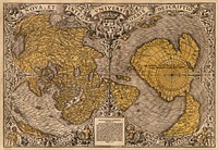
Nova totius terrarum orbis geographica ac hydrographica (ca. 1635–1650) by Guiljelmo Blaeuw. Original from The…
https://www.rawpixel.com/image/2041467/nova-totius-terrarum-orbis-geographica-hyd
Free Image from public domain license
Color plan of the 1942 Rome World's Fair (1939) by Arti grafiche Pizzi & Pizio. Original from The Beinecke Rare Book &…
https://www.rawpixel.com/image/2038929/color-plan-the-1942-rome-worlds-fair
Free Image from public domain license