https://creativecommons.org/publicdomain/zero/1.0/https://www.rawpixel.com/image/9976079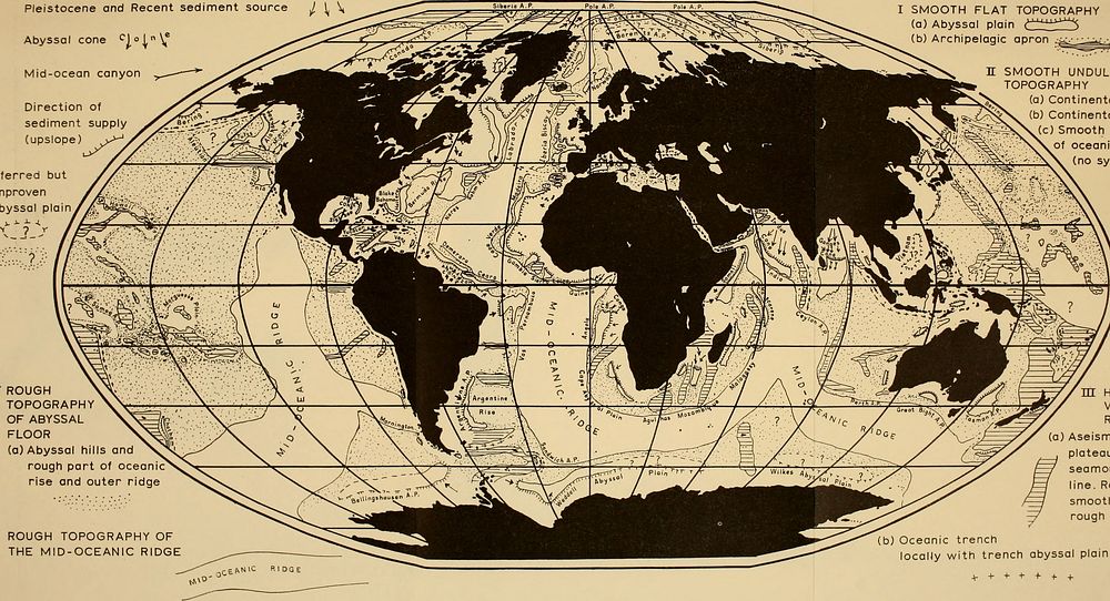
Title: The Earth beneath the sea : HistoryIdentifier: earthbeneathseah00hill (find matches)Year: 1963 (1960s)Authors: Hill, M. N. (Maurice Neville), 1919-Subjects: Ocean bottom; Marine geophysicsPublisher: New York : Interscience Pub.Contributing Library: MBLWHOI LibraryDigitizing Sponsor: MBLWHOI LibraryView Book Page: Book ViewerAbout This Book: Catalog EntryView All Images: All Images From BookClick here to view book online to see this illustration in context in a browseable online version of this book.Text Appearing Before Image:Pleistocene and Recent sediment source / \ \ Abyssal cone '^j.°;"\,* Mid-ocean canyon Direction of sediment supply (upslope) I SMOOTH FLAT TOPOGRAPHY (a) Abyssal plain ^^'â '^^^â '^ (b) Archipelagic apron .â ,^._ n SMOOTH UNDULATING TOPOGRAPHY (a) Continental shelf (b) Continental rise (c) Smooth parts of oceanic rise (no symbol) Inferred but unproven abyssal plainText Appearing After Image:IV ROUGH TOPOGRAPHY OF ABYSSAL FLOOR (a) Abyssal hills and rough part of oceanic rise and outer ridge V ROUGH TOPOGRAPHY OF THE MID-OCEANIC RIDGE m HIGH VERTICAL RELIEF (a) Aseismic ridge plateau and seamount-island ine. Relatively smooth locally rough (b) Oceanic trench locally with trench abyssal plain Fig. 2. Distribution of smooth and rough topography in the world ocean. (North Atlantic after Heezen, Tharp and Ewing, 1959 ; South Atlantic after Heezen and Tharp, 1961; Indian Ocean after Heezen and Tharp, in press; Pacific Archipelagic Aprons after Menard, 1956 ; Arctic after Dietz and Shumway, 1961.)Note About ImagesPlease note that these images are extracted from scanned page images that may have been digitally enhanced for readability - coloration and appearance of these illustrations may not perfectly resemble the original work.
Title: The Earth beneath the sea : HistoryIdentifier: earthbeneathseah00hill (find matches)Year: 1963 (1960s)Authors: Hill, M. N. (Maurice Neville), 1919-Subjects: Ocean bottom; Marine geophysicsPublisher: New York : Interscience Pub.Contributing Library: MBLWHOI LibraryDigitizing Sponsor: MBLWHOI LibraryView Book Page: Book ViewerAbout This Book: Catalog EntryView All Images: All Images From BookClick here to view book online to see this illustration in context in a browseable online version of this book.Text Appearing Before Image:Pleistocene and Recent sediment source / \ \ Abyssal cone '^j.°;"\,* Mid-ocean canyon Direction of sediment supply (upslope) I SMOOTH FLAT TOPOGRAPHY (a) Abyssal plain ^^'â '^^^â '^ (b) Archipelagic apron .â ,^._ n SMOOTH UNDULATING TOPOGRAPHY (a) Continental shelf (b) Continental rise (c) Smooth parts of oceanic rise (no symbol) Inferred but unproven abyssal plainText Appearing After Image:IV ROUGH TOPOGRAPHY OF ABYSSAL FLOOR (a) Abyssal hills and rough part of oceanic rise and outer ridge V ROUGH TOPOGRAPHY OF THE MID-OCEANIC RIDGE m HIGH VERTICAL RELIEF (a) Aseismic ridge plateau and seamount-island ine. Relatively smooth locally rough (b) Oceanic trench locally with trench abyssal plain Fig. 2. Distribution of smooth and rough topography in the world ocean. (North Atlantic after Heezen, Tharp and Ewing, 1959 ; South Atlantic after Heezen and Tharp, 1961; Indian Ocean after Heezen and Tharp, in press; Pacific Archipelagic Aprons after Menard, 1956 ; Arctic after Dietz and Shumway, 1961.)Note About ImagesPlease note that these images are extracted from scanned page images that may have been digitally enhanced for readability - coloration and appearance of these illustrations may not perfectly resemble the original work.
Original public domain image from Wikimedia Commons
Public DomainFree CC0 image for Personal and Business use