https://creativecommons.org/publicdomain/zero/1.0/https://www.rawpixel.com/image/7667116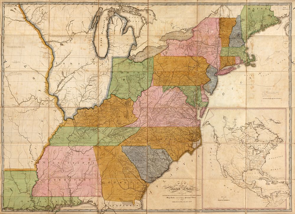
![Map of the United States : exhibiting the post-roads, the situations, connexions & distances of the post-offices, stage roads, counties & principal rivers; Scale [ca. 1:1,940,000]; [5th ed.] Philadelphia : Made and sold by Caldcleugh and Thomas, [1804] Relief shown pictorially. Also shows townships in parts of Maine, New York, and Indiana Territory. Illinois (not named) is shown as part of Indiana Territory. Slipcase title and publisher's statement from printed labels affixed to slipcase. Earliest state of the 5th ed. Prime meridian: Washington D.C. "Entered according to the Act of Congress the 2nd day of June 1804 by Abraham Bradley Jun'r of the District of Columbia." Sectioned (to 36 panels) and mounted on cloth backing to fold to 23 x 17 cm. Imperfect: Lightly foxed, worm-holed in margin, slip-case flattened. Includes notes in map area and inset "Map of North America" (scale ca. 1:17,000,000).](https://images.rawpixel.com/image_200/cHJpdmF0ZS9sci9pbWFnZXMvd2Vic2l0ZS8yMDIyLTA4L2xyL3drNzAyNjYyNy1pbWFnZS5qcGc.jpg)
Map of the United States : exhibiting the post-roads, the situations, connexions & distances of the post-offices, stage roads, counties & principal rivers; Scale [ca. 1:1,940,000]; [5th ed.] Philadelphia : Made and sold by Caldcleugh and Thomas, [1804] Relief shown pictorially. Also shows townships in parts of Maine, New York, and Indiana Territory. Illinois (not named) is shown as part of Indiana Territory. Slipcase title and publisher's statement from printed labels affixed to slipcase. Earliest state of the 5th ed. Prime meridian: Washington D.C. "Entered according to the Act of Congress the 2nd day of June 1804 by Abraham Bradley Jun'r of the District of Columbia." Sectioned (to 36 panels) and mounted on cloth backing to fold to 23 x 17 cm. Imperfect: Lightly foxed, worm-holed in margin, slip-case flattened. Includes notes in map area and inset "Map of North America" (scale ca. 1:17,000,000).
Map of the United States : exhibiting the post-roads, the situations, connexions & distances of the post-offices, stage roads, counties & principal rivers; Scale [ca. 1:1,940,000]; [5th ed.] Philadelphia : Made and sold by Caldcleugh and Thomas, [1804] Relief shown pictorially. Also shows townships in parts of Maine, New York, and Indiana Territory. Illinois (not named) is shown as part of Indiana Territory. Slipcase title and publisher's statement from printed labels affixed to slipcase. Earliest state of the 5th ed. Prime meridian: Washington D.C. "Entered according to the Act of Congress the 2nd day of June 1804 by Abraham Bradley Jun'r of the District of Columbia." Sectioned (to 36 panels) and mounted on cloth backing to fold to 23 x 17 cm. Imperfect: Lightly foxed, worm-holed in margin, slip-case flattened. Includes notes in map area and inset "Map of North America" (scale ca. 1:17,000,000).
Original public domain image from Wikimedia Commons
Public DomainFree CC0 image for Personal and Business use